
CLIMATE
Jamaica's climate is mainly sub tropical or tropical maritime. The most important broad-scale climatic influences are the North East Trade Winds and the island’s orographic features,
(mainly the eastern Blue & John Crow Mountains and the Central Ridge of mountains and hills). Other influences are the warm waters of the Caribbean Sea, as well as synoptic weather systems such as:
the Azores-Bermuda high-pressure system; surface, mid and upper level troughs; frontal systems; easterly waves; tropical depressions; tropical storms; hurricanes; and infrequently, the inter-tropical convergence zone.
Apart from day vs. night solar patterns, clouds and rainfall are the dominant meteorological variables that influence the meso-scale fluctuations of temperature, humidity, visible and UV light, and evaporation. Similar to all the other countries of the Caribbean, Central America and the Southern and Eastern sections of the United States, Jamaica is impacted from time to time by severe tropical weather systems including tropical waves, tropical depressions, tropical storms and hurricanes. The official hurricane season is from June to November, although cyclones have occurred outside this period. El Niño Southern Oscillation Effect (ENSO) is superimposed on this system and leads to regular fluctuations on a 5 to 7 year timeframe.
RAINFALL
Most rainfall is due to convection and orographic effects. Seasonal distribution is marked. In the cool months December to March, convectional rainfall is at a minimum and, apart from cold fronts, the very limited precipitation at this time is mainly orographic. The May-June rains are mainly convectional. In August the regional synoptic setting results in convergence rains augmented by convection. A general increase in humidity in the Caribbean and the passage of a series of squall lines produces the wet season of September, October and November, which is at a maximum in October.
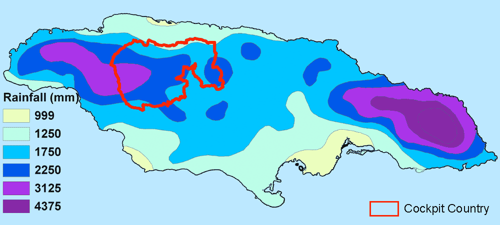
The rainfall within the Martha Brae Watershed clearly reflects the influence of topography and there is a contrasting rainfall regime north and south of a line, roughly corresponding to the 200 m contour, between Adelphi and Kinloss -- the northern boundary of Cockpit Country. We have available daily records of rainfall at Windsor since 1996.
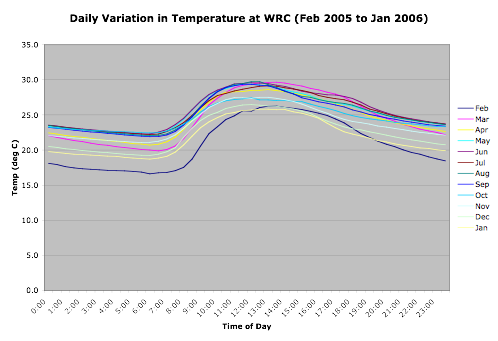
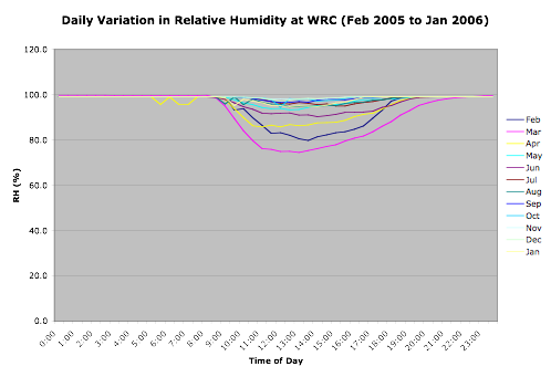 These graphs show the daily variation at Windsor over a one-year period. It should be noted that we are located in a fairly open glade: humidity would be higher in a closed sink!