
Thus, on New Year's Eve, those people whom NEPA deemed to be stakeholders (and, by the way, this didn't include everyone who submitted review comments on the EIAs for SML-173!!) were given a holiday weekend to prepare for whatever news we would learn from NEPA.
To say the timing and short notification were red flags of sneaky, disingenous behaviour is an understatement. Dr. Susan will now walk readers through the salient items of what she can only describe as a "smoke-and-mirrors" con job, which will lead to the sacrificing of communiities in northeastern Cockpit Country and, in fact, the sacrificing of communities in central St. Ann as well to bauxite mining.
|
1.1. Why is NEPA not using the boundary of the CCPPA which Forestry Department finished ground-truthing in its entirety by March 31st, 2021? 1.2. Is NEPA aware that a small section in the southwest corner of SML-165 overlaps with the ground-truthed CCPPA? 1.3. Should the public have any confidence that NEPA / the NRCA won't issue Environmental Permits for mining that encroaches the CCPPA? 1.4. What confidence should we have that government agencies can detect breaches (e.g., such as if Noranda were to undertake mining activities (incl. haul road construction) outside of permitted boundaries) if the agencies are not using the same GIS database files? |
|
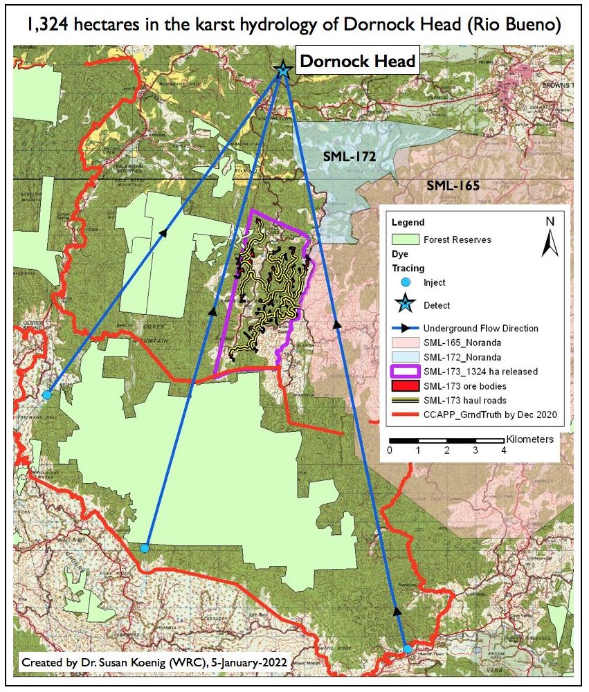
2.1. Firstly, NEPA's math is wrong. As communicated to Dr. Susan by Forestry Department on 12-January-2022, there are 1,289 hectares of Forest Estates (Reserves + Crown Land) within SML-173, not 1,281 as presented by NEPA. Mathematically, this is a small mistake, but it takes us back to item 1.3 to beg the question: should we have confidence that NEPA can do its job using GIS? 2.2. Adjacent to the largest block of Forest Estates (it's actually 2 Reserves + Brislington Crown Land) is an 891-hectare area called the "Clawed Back Area". As per the Environmental Impact Assessment (EIA), these hectares were going to be taken back from NJBP II, so no mining would be allowed. The reason given was that, because bauxite mining will impact the farmers of Sawyers and Level Bottom (Trelawny), lands within the Clawed-Back Area should be excluded from mining. From the EIA, pg 7-14:
This of course begs the question: if the farmers of Sawyers and Level Bottom were given this special consideration, why did not ALL of the farming communities within SML-173 deserve to be protected? On the face of it, the identification of Sawyers and Level Bottom's protective exclusion appears capricious . . .but Dr. Susan has no doubt there is a reason for this Clawed-Back Area. 2.3. According to Mr. Knight, the 891 hectares of the Clawed-Back Area are going to be added to the CCPPA, so they will be protected legally from bauxite mining (if and when the CCPPA is gazetted and then declared Closed to Mining . . .)
2.4. The adjacent Forest Reserves, however, will NOT be added to the CCPPA. Dr. Susan cannot emphasize the following too strongly:
|
|
Click here for Dr. Susan's counter-view -- her submitted comments to NEPA of the so-called "final" version of the EIA and the associated public meeting. Dr. Susan categorically rejects the entire EIA for SML-173. |
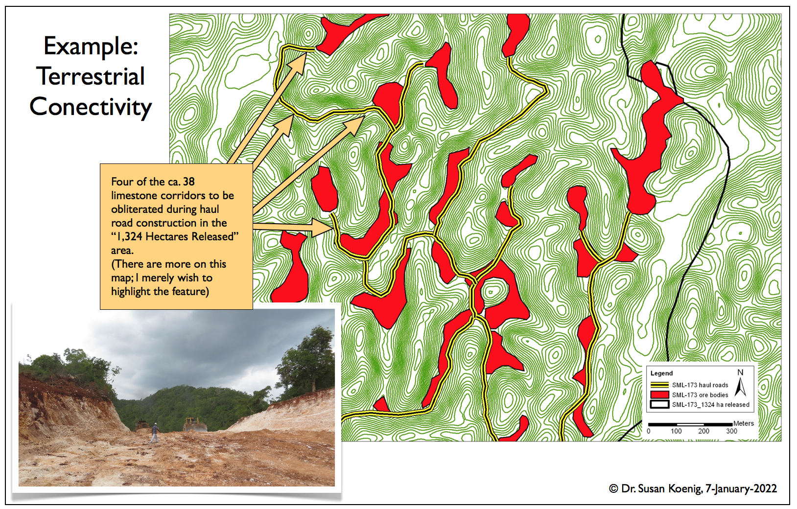
UPDATED 7-FEBRUARY-2022: NEPA issued two Environmental Permits to NJBP II which covered 1,333 hectares. Stay tuned for more webpages, where Dr. Susan will explain NEPA's mapping problems. With this map, all of Mr. Knight's words about science guiding the decision-making process flew out the window. All of his credibility was lost because what this map showed us was merely that NJBP II's desired area for its first 5-year mining plan, as was identified by the EIA, will be given to them for mining. Indeed, Mr. Knight confirmed during his speech that this area was "Phase I" of NJBP II's mining plan. Here are a few examples of the science which was ignored:
|
|