
 |
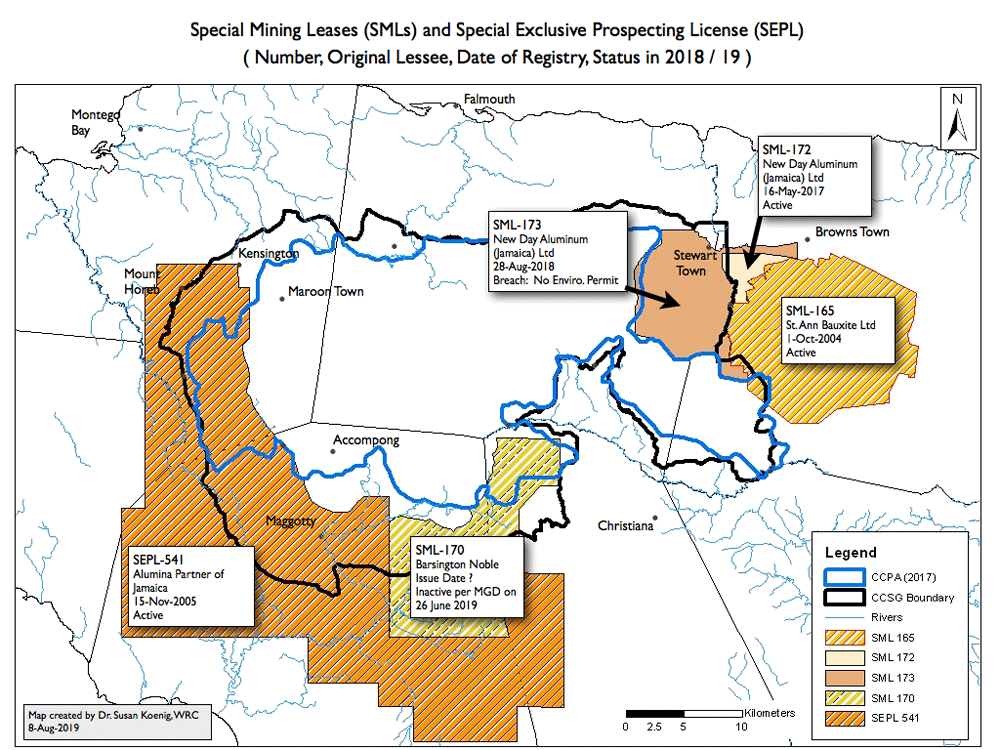
The CCPA (2017) boundary, however, made immediate sense when the Prime Minister revealed "Map 7 - Cockpit Country Protected Area with Existing Mining Licences (sic)" (this map appears on pg 11 of his speech). We have updated "Map 7" to show the status of the Special Mining Leases (SMLs) and Special Exclusive Prospecting License (SEPL), as known to us on 22 August 2019.
Pay particular attention to the fact that SML-173 will irreversibly impact both the proven hydrology of Dornock Head & Rio Bueno and cultural heitage, including a Maroon Path leading from Hectors River to Mahogany Hall (near Stewart Town).
|
2020-DEC-31 UPDATE: SML-173 was granted to New Day Aluminum (Jamaica) Ltd. on 28th-August-2018, with the signature of the Minister of Transport & Mining, Robert Montague. This represents a breach because
before an SML can be issued, it must first have an Environmental Permit from NEPA / NRCA. Noranda Jamaica Bauxite Partners II, a partnership between New Day and Government of Jamaica (GoJ), has since been scrambling
to fulfill NEPA's requirement that an Environmental Impact Assessment (EIA) must be conducted before an Environmental Permit can be issued. Thus, we are in the situation where GoJ is a
propoenent for mining and a partner through business ownership while at the same time it is the regulator tasked with protecting natural resources.
WRC's Dr. Susan Koenig reviewed the EIA, which was prepared by Conrad Douglas & Associates, Ltd and presented to the public on 8th December 2020. In her opinion, when NJBP II approved this EIA as "acceptable for submission to NEPA and for presentation to the public", GoJ demonstrated that a functional cockpit karst ecosystem, with its myriad ecosystem services, is of little-to-no concern and that the EIA process is merely something to "check off from a list" - a complete farce and a sham. It is clear as to why this area of Cockpit Country was excluded from the Protected Area boundary. Click here to view Dr. Susan's review. To read the EIA and its associated documents, visit NEPA's website https://www.nepa.gov.jm/environmental-impact-assessments |
The CCPA also fails to protect the Black River, Montego River and Great River from mining in the south and western regions of Cockpit Country.
TECHNICAL NOTE: The CCPA-2017 boundary shown on the above map was created by Dr. Susan Koenig in ArcMap GIS software by hand-tracing the boundary
presented by the Prime Minister to Parliament on November 21st, 2017. The first map we received (dated Jan-19-2018) via an ATI request showed minor changes from the
map presented on November 2017. Whenever Dr. Koenig creates a new map showing the CCPA-2017 boundary, she always uses the original boundary of November 21st, 2017 to prevent confusion.
Boundaries for SMLs and SEPLs were obtained using Access-to-Information requests.
Because ground-truthing of the CCPA boundary is on-going, members of the public should always consult with Jamaica's Forestry Department for current information about the boundary.
UPDATE: August 31st, 2021
Forestry Department reports that that ground-truthing is completed for what they call the Cockpit Country Area Proposed for Protection (CCAPP). The perimter has a length of 253.27 km and it encloses 77,182 hectares of private and public lands. However, the National Land Agency has not been able to successfully engage a Commissioned Land Surveyor, so the boundary cannot be gazetted or closed to mining as yet.
| Boundaries Home Page |